Unofficial Kiowa County 2022 General Election Results
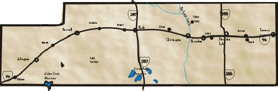
Arlington
Brandon
Chivington
Eads
Galatea
Haswell
Sheridan Lake
Towner
Sand Creek Massacre National
Historic Site
-
COUNTY
OFFICES
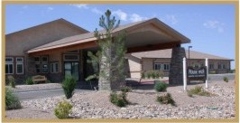
The
Kiowa County Courthouse,
Social
Services and
Public
Health offices
New business hours
Effective January 1, 2022;
8:00
a.m. to 5:00 p.m. Monday - Thursday.
Offices no longer open on Fridays
Kiowa
County Public Library
Open
Tuesday - Thursday 8:00 to 5:00.
Friday 8:00 am - 4:00 pm

1305 Goff St
Eads, CO 81036
719.438.5521

1305 Goff St
Eads, CO 81036
719.438.5421

1305 Goff St
Eads, CO 81036
719.438.5810

1305 Goff St
Eads, CO 81036

1307 Maine St.
Eads CO 81036
719.438.5541

1309 Maine St
Eads CO 81036
719.438.5782

1305 Goff St
Eads, CO 81036
719.438.5411

1305 Goff St
Eads, CO 81036
719.438.5831

1305 Goff St.
Eads, CO 81036
719-438-5860

Kiowa County Historic Preservation Commission

1305 Goff St
Eads, CO 81036
Phone: 719.438.5581
Saturday – Monday: Closed
Tuesday – Thursday: 8:00 AM – 5:00 PM
Friday: 8:00 AM – 4:00 PM
Kiowa County Commissioners Office
1305 Goff
719-438-5810
|
Welcome to Kiowa County-Colorado
Kiowa County was created on April 11 1889, taking
its name for the Kiowa Indians, is located on the eastern
edge of Colorado. To the north borders Cheyenne Co, west is
Lincoln Co and Crowley Co, Otero Co, Bent Co and Prowers Co
on the south. Kiowa Co shares the east border with the state
of Kansas.
KiowaCounty-Colorado.com on
Facebook

|

|